Ochiltree residents tree logo
Ochiltree residentsPlanning application 26/0511/PP

Time left to object

--days
--hours
--minutes
--seconds

Comments close at the end of Monday 23 November 2026

Months to prepare, weeks to respond

  1. Early 2026Pre-application advice sought from the council
  2. Jul–AugOdour, noise and drainage studies prepared
  3. 29 SepApplication submitted, 25 documents
  4. End OctNeighbours notified
  5. 23 NovComments close

The applicant's team has had most of a year. Residents have about three weeks to read 25 technical documents and respond.

A 32,000-hen commercial egg factory unit, 800 m from Ochiltree

A large commercial egg factory unit is proposed in open fields off Station Road, our residential street, on land north of Palmerston Barn. Here is what it would mean for the village, and how to have your say before the deadline.

Drone footage from Ochiltree south over the Burnock Water to the site. The marked position at the end is approximate. 31 seconds, no sound.
32,000hens in one building
122.6 mlong, longer than a full-size football pitch
800 mfrom the edge of the village
120–150 mfrom the nearest homes, downwind

Have your say

How to object before 23 November

Every household can comment. Separate letters in your own words carry more weight than copies of one letter.

  1. Find the application

    Go to East Ayrshire Council's online planning service and search for the reference:

    26/0511/PP
  2. Write your own comment

    Use the comments section on the application page, or write to the council's planning department. Give your full name and address, or your comment may not be counted.

  3. Stick to planning points

    Traffic on Station Road, smell, Poultry Dust and bioaerosols reaching homes, the primary school and the Hub, risk to the Burnock Water, landscape, siting away from the existing farm, and the missing biohazard assessment.

  4. Ask for the right things

    Ask for the application to be refused, or at least for a biohazard (Poultry Dust and bioaerosol) assessment, local odour modelling and a traffic plan for Station Road before any decision. You can also ask your ward councillors to have it decided by the Planning Committee rather than by an officer.

Include

  • How it would affect your home and the village
  • Specific facts, such as distances and lorry numbers
  • The deadline: Monday 23 November 2026

Leave out

  • Comments about the applicant personally
  • Property values
  • General opposition to farming

What's proposed

An industrial-scale building in open countryside

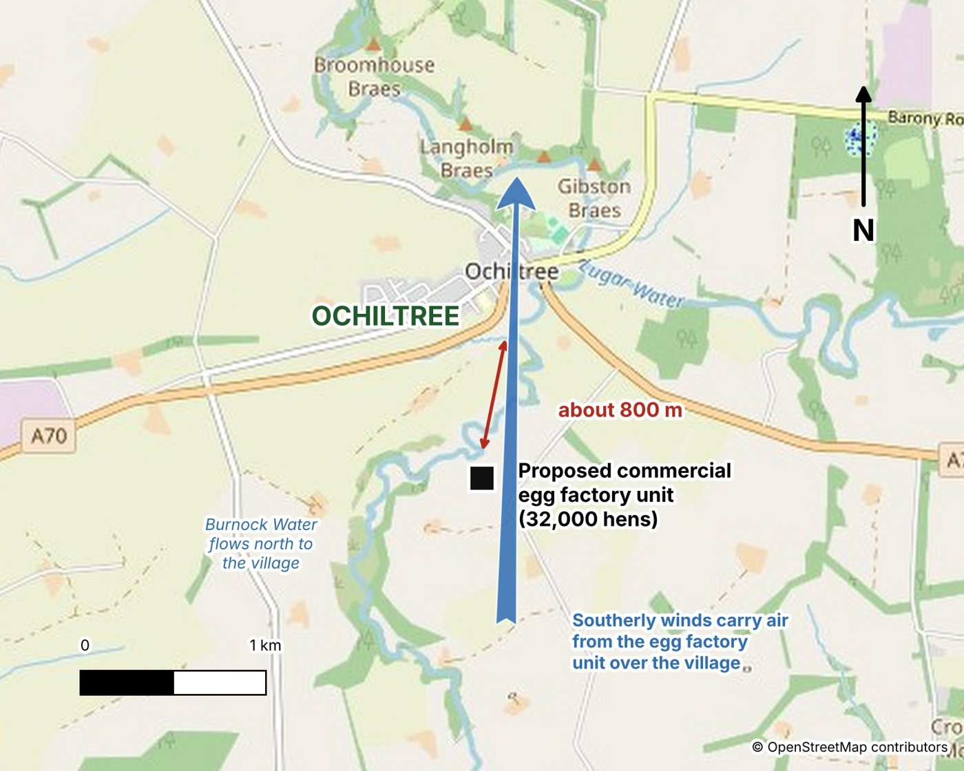
Map showing the proposed unit about 800 m south of Ochiltree, with the Burnock Water flowing north to the village and southerly winds carrying air over it
The site, the Burnock Water and the direction southerly winds carry air. Map © OpenStreetMap contributors.

The applicant is Clearfield Poultry Ltd, with Harrison Pick Ltd as agent. The application is for:

  • One shed 122.6 m by 24.7 m, about 17 m longer than a full-size football pitch (105 m), with roof extract fans running day and night and feed silos.
  • Hardstanding, a dirty water tank, an access track and a soakaway on the slope above the Burnock Water.
  • About 37,000 m³ of earth moved over 26–32 weeks of construction, building a platform up to 7.6 m high on the side facing the burn.

Figures from the application documents (Planning Statement, Site Sections, Construction Management Plan).

Location plan and distances

How close it really is

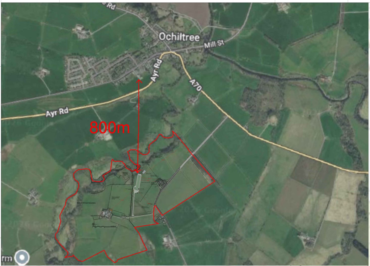
Aerial location plan showing the application site and Back o' Hill land outlined in red, 800 m south of Ochiltree
Location plan: the site is about 800 m from the edge of Ochiltree. Aerial imagery © Google.

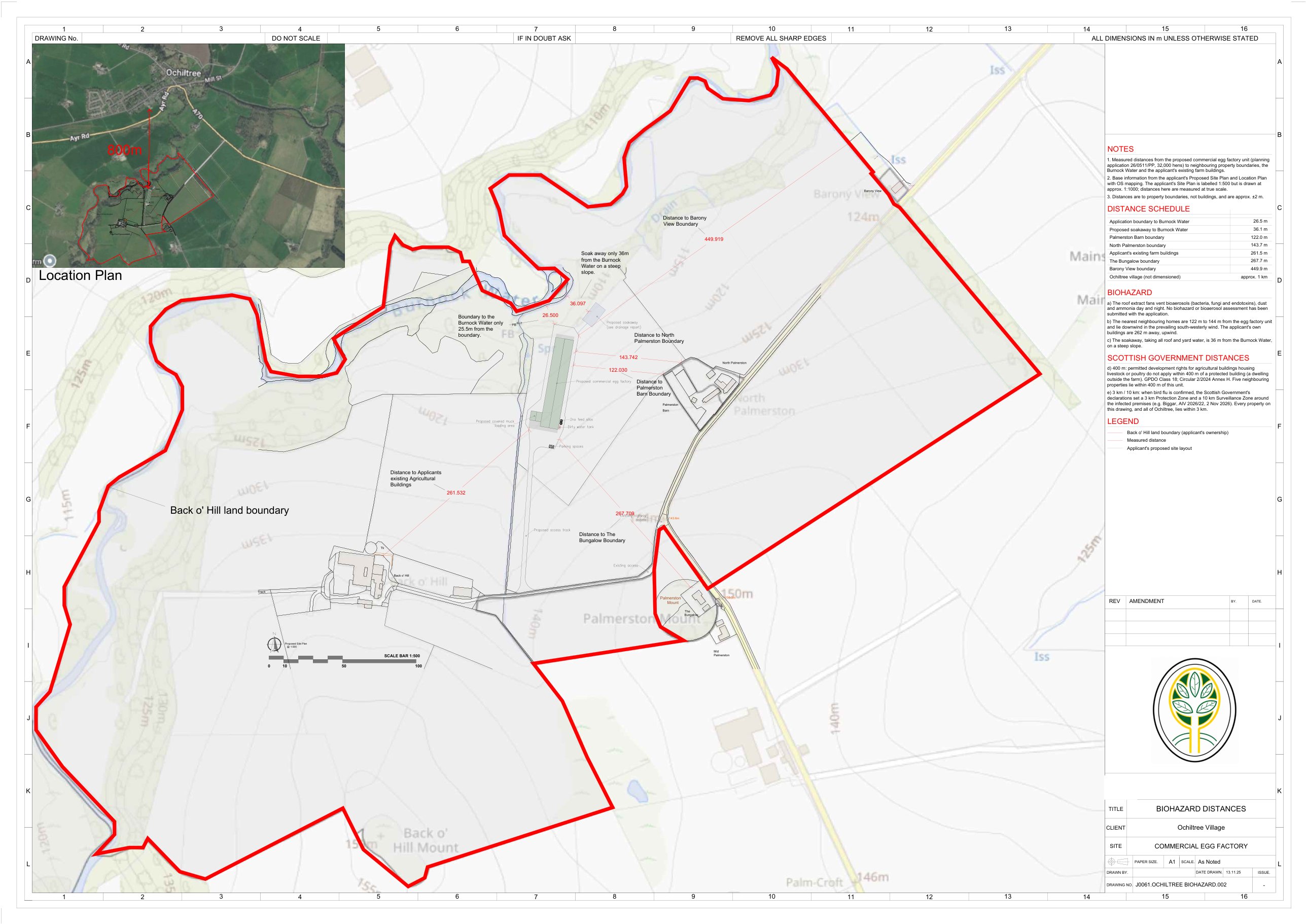
Measured distances to property boundaries.

From the egg factory unit toDistance
Burnock Water, from the site boundary26.5 m
Burnock Water, from the soakaway36.1 m
Palmerston Barn122.0 m
North Palmerston143.7 m
The applicant's own farm buildings261.5 m
The Bungalow267.7 m
Barony View449.9 m
Ochiltree village800 m

The nearest homes are closer to the unit than the applicant's own farmhouse is, and they sit downwind of it. Five neighbouring properties lie within 400 m, the distance within which the Scottish Government's planning rules take away permitted development rights for livestock buildings.

Biohazard distances drawing showing the proposed unit, the Back o' Hill land boundary in red and measured distances to each neighbouring property and the Burnock Water

What it would mean for Ochiltree

Traffic, smell, Poultry Dust and the burn

1Traffic on Station Road

  • Building it: up to 8 lorry movements a day during earthworks and up to 10 a day for concrete, for 6–8 months.
  • Running it: feed and egg artics every week, manure loads twice a week and 8 artics at each flock change.
  • Station Road is a single-track residential street with no formal passing places. Lorries already run onto verges and use driveways to pass.
  • The passing places and sightlines the council asked for are not shown.
2Smell

  • Roughly 1,800 tonnes of manure a year taken out twice a week, to be spread on farmland or sent to an anaerobic digester.
  • Southerly winds blow straight from the site over the village, about 1 hour in 8 in the applicant's own wind data.
  • The odour model only predicts 2.54 at the nearest house against a 3.0 limit, using regional rather than local weather for a river valley.
  • On a warm summer day Ochiltree will be absolutely reekin!

3Poultry Dust, air and biohazard

  • The fans vent Poultry Dust, ammonia and bioaerosols: a biohazard of airborne bacteria, fungi and endotoxins.
  • No Poultry Dust or bioaerosol assessment has been submitted.
  • At 32,000 birds it is under the 40,000 limit for a SEPA permit, so once running no environmental regulator controls its emissions. Planning is the only control.
Search “Poultry Dust” on Google

4The Burnock Water

  • The shed sits about 30–50 m from the burn, which flows north through Ochiltree to the Lugar Water.
  • It is a Local Nature Conservation Site and a trout spawning burn. The applicant's own report rates the pollution risk as High before mitigation.
  • All roof and yard water goes to one soakaway, designed on a single trial pit.

5Views and landscape

  • Sited mid-field inside a Local Landscape Area, about 300 m from the existing farm buildings.
  • The council's pre-application advice called it larger than most farm buildings in East Ayrshire.
  • No photomontages have been submitted.

6Noise

  • Roof fans run around the clock. The noise assessment only passes if every fan has a silencer.
  • Background noise was measured in August underneath trees in full leaf, which makes the fans look quieter by comparison.

Children and the community

Ochiltree Primary School and the Hub

About 1 kmOchiltree Primary School and the Ochiltree Hub on Main Street are both about 1 km due north of the proposed unit.
In the wind's pathSoutherly winds, about 1 hour in 8 in the applicant's own wind data, carry air from the roof fans straight towards them.
Not assessedThe application mentions the school only once, to keep construction deliveries away from drop-off and pick-up times. Nothing assesses Poultry Dust or bioaerosols reaching the school or the Hub.
Inside 3 kmBoth would be inside the bird flu Protection Zone if an outbreak were confirmed at the unit.

Schoolchildren are among the most sensitive people to Poultry Dust and air quality. Ask the council to require a biohazard (Poultry Dust and bioaerosol) assessment that covers the school and the Hub.

Biohazard

A biohazard, not just “agricultural”

39times the Planning Statement calls it “agricultural”
0mentions of bird flu, avian influenza or bioaerosols across all 25 documents

Biosecurity is mentioned only 3 times in the whole application.

  • Airborne biohazard: roof fans vent bioaerosols (bacteria, fungi and endotoxins), Poultry Dust and ammonia, day and night.
  • Blowing over Ochiltree: the village lies due north of the unit. Whenever the wind is from the south, about 1 hour in 8 in the applicant's own wind data, that airborne biohazard is carried straight over Ochiltree, the primary school and the Hub. On the more common south-westerly wind it blows over the nearest homes on Station Road.
  • Disease biohazard: H5N1 bird flu is a notifiable disease. One confirmed case triggers emergency control zones.
  • Waste biohazard: roughly 1,800 tonnes of manure a year, dirty water and dead birds to store and remove.

Bird flu control zones

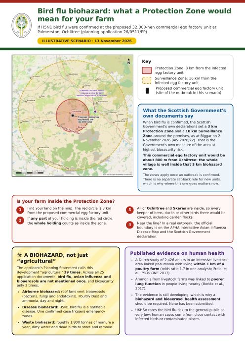
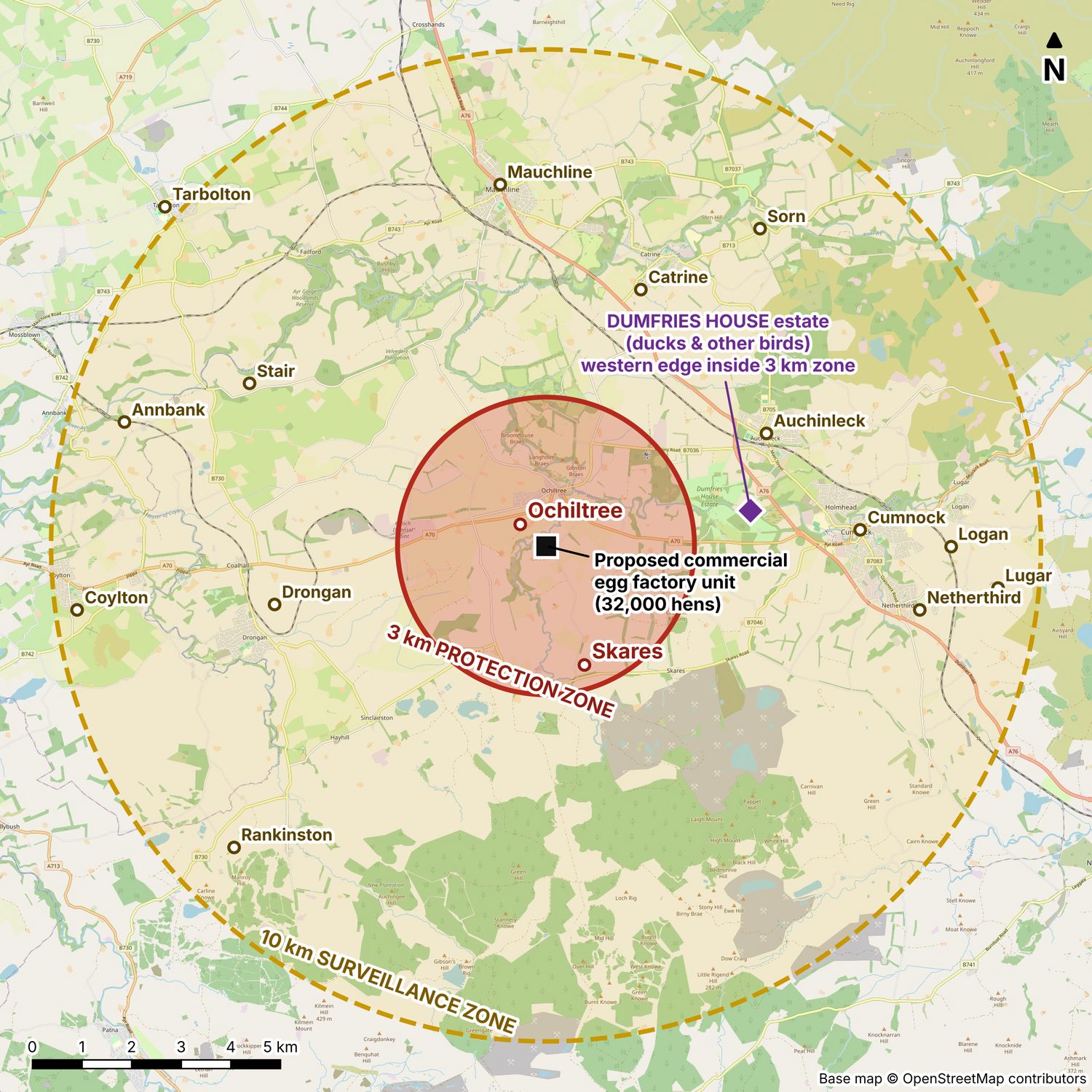
The whole village would be inside the 3 km Protection Zone

When bird flu is confirmed, the Scottish Government's own declarations set a 3 km Protection Zone and a 10 km Surveillance Zone around the infected premises. That is the Government's own measure of the area at highest biosecurity risk.

Map of a 3 km Protection Zone and 10 km Surveillance Zone around the proposed site, covering Ochiltree, Skares and towns from Mauchline to Cumnock, with Dumfries House estate marked
Illustrative zones if bird flu were confirmed at the proposed site. Real zones are declared by the Scottish Government. Map © OpenStreetMap contributors.

It has just happened at Biggar

H5N1 was confirmed in a commercial free-range laying flock near Biggar on 2 November 2026 (Scottish Government ref. AIV 2026/22). Zones were declared the same day and are still in force. A Scotland-wide Avian Influenza Prevention Zone followed on 10 November.

Inside 3 km: Ochiltree and Skares

  • That includes Ochiltree Primary School and the Hub, both about 1 km away.
  • Anyone with garden hens or ducks must house them, keep records and expect inspection.
  • No eggs given away or sold, and no birds, eggs or manure moved without a licence.
  • No bird shows, sales or gatherings, and game birds must not be released.
  • The turkey farm at Knockshiffnock, about 2 km away, could move no birds or eggs without a licence, at the height of the Christmas trade if it happened in November or December.
  • The western edge of the Dumfries House estate is inside 3 km, putting its ducks and other birds under the strictest controls.

Inside 10 km

Auchinleck, Catrine, Drongan, Cumnock, Stair, Mauchline, Sorn, Netherthird, Logan, Rankinston, Annbank, Lugar, Coylton, and Dumfries House itself.

Restrictions usually last a month or more, longer if there are further cases. The zones apply once an outbreak is confirmed; they are not a siting rule for new units, which is why where this one goes matters now.

Wild birds come and go, but siting a permanent biohazard source 800 m from a village is a choice.

Happening now

The ongoing outbreak near Biggar

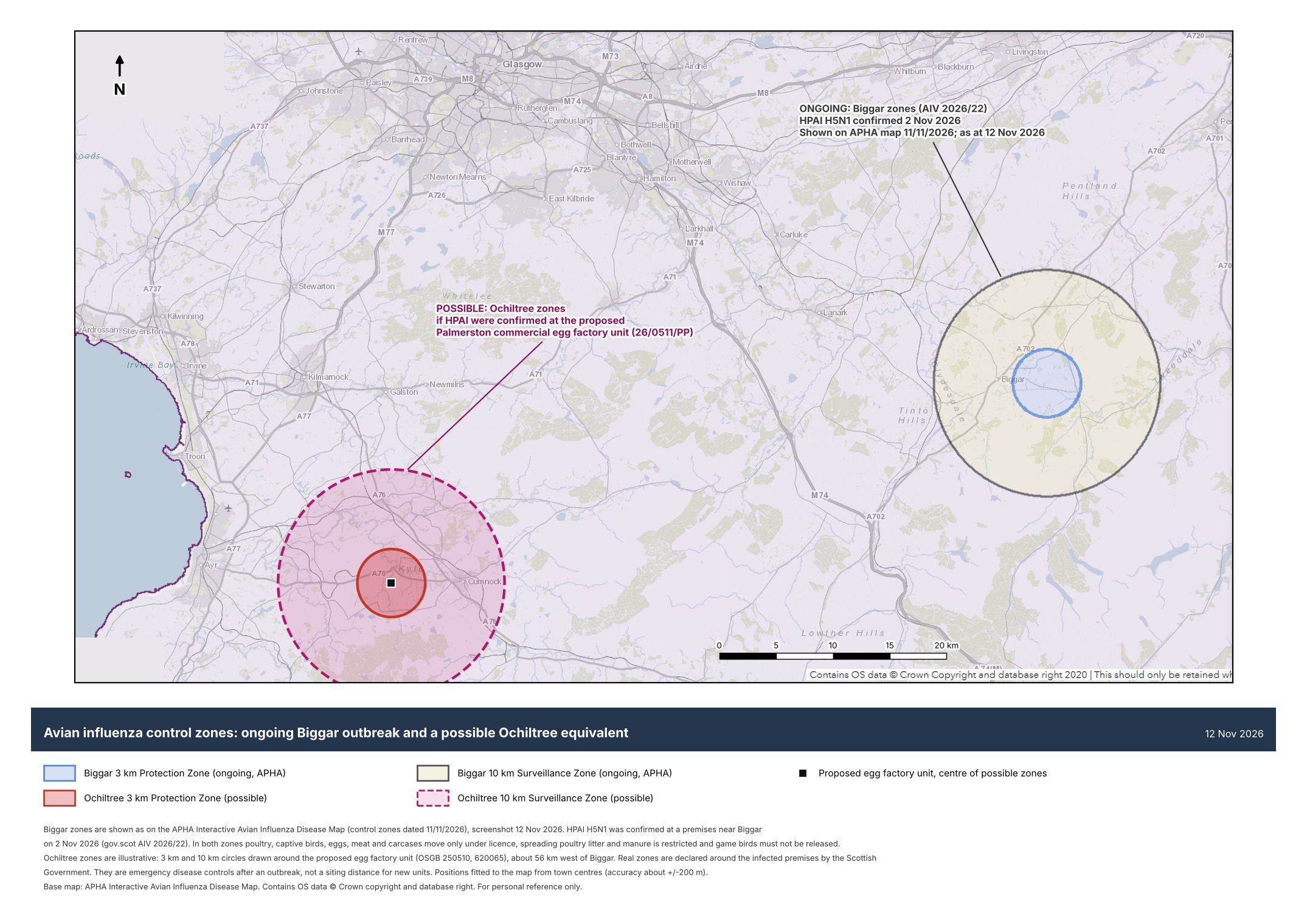
Bird flu is not a distant risk. Less than two weeks ago it was confirmed in a commercial free-range laying flock near Biggar, the same kind of unit that is proposed here.

Map comparing the ongoing Biggar 3 km and 10 km control zones with the zones that would be declared around the proposed Ochiltree unit, about 56 km to the west
The ongoing Biggar zones as shown on the APHA map, beside the zones that would be declared around the Ochiltree site. Base map: APHA Interactive Avian Influenza Disease Map, contains OS data © Crown copyright.
  • 2 November 2026: highly pathogenic H5N1 confirmed in a commercial free-range laying flock near Biggar, in the Scottish Borders (Scottish Government ref. AIV 2026/22).
  • A 3 km Protection Zone and 10 km Surveillance Zone were declared that evening.
  • Inside both zones, game birds must not be released, and birds, eggs, carcases, litter and manure can only move under licence.
  • As of 12 November the Scottish Government still lists it as a current outbreak. The zones stay until disease control and surveillance are finished.
  • 10 November 2026: a Scotland-wide Avian Influenza Prevention Zone was declared.

The APHA map is the official Animal and Plant Health Agency disease map and opens on the Biggar area in a new tab.

Health

What the published evidence says

The research is still developing, which is exactly why a biohazard and bioaerosol health assessment should be required before any decision. None has been submitted.

Pneumonia within 1 km

A Dutch study of 2,426 adults in an intensive livestock area linked pneumonia with living within 1 km of a poultry farm, with an odds ratio of 1.7 in one analysis.

Freidl et al., PLOS ONE, 2017

Ammonia and lungs

Ammonia from livestock farms was linked to poorer lung function in people living nearby.

Borlée et al., 2017

Bird flu risk to the public

UKHSA rates the risk to the general public as very low. Human cases come from close contact with infected birds or contaminated places.

UKHSA, 2025

There is a better answer

Better sites exist

Sites beside the existing farm steading would be further from the village, the Burnock Water and neighbouring homes, and would need far less earthworks. No alternative site has been assessed in the application.

  • No neighbouring houses within 400 m.
  • About 13–65% of the earthworks of the current proposal.
  • 150–250 m from the burn.

Print and share

The flyers

A one-page flyer and three two-page A4 flyers to print and hand round, plus the distances drawing.

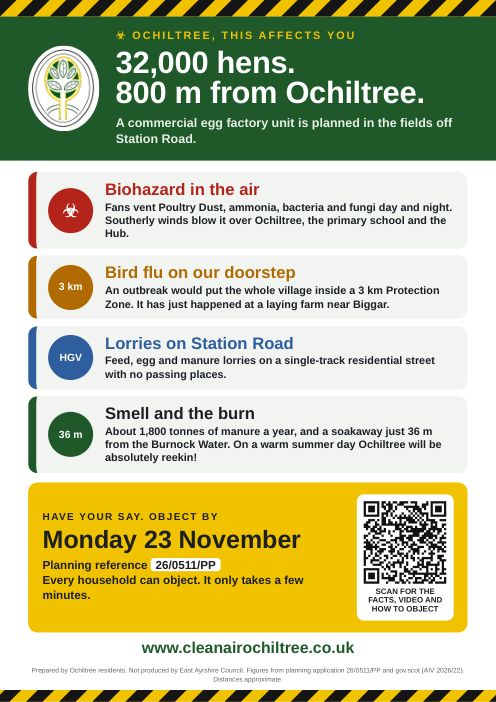
The one-page Clean Air Ochiltree flyer

Clean Air Ochiltree flyer

One page, big text and a QR code to this website. Ideal for letterboxes and noticeboards.

Download PDF
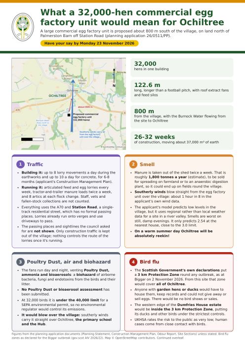
First page of the village flyer

Village flyer

Traffic, smell, Poultry Dust, the burn and how to object. For every household.

Download PDF
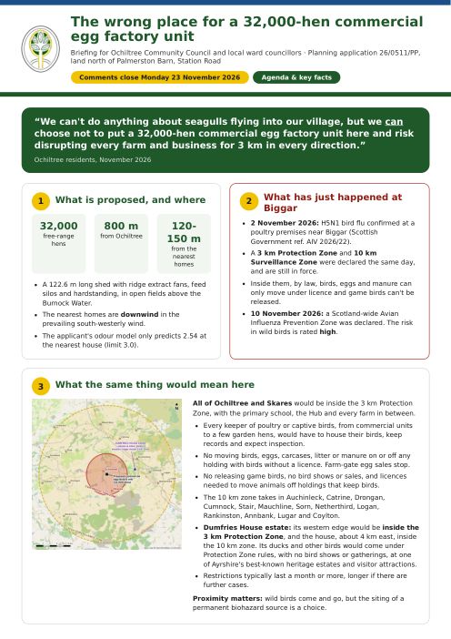
First page of the Ochiltree briefing

Ochiltree briefing

The full case against the egg factory unit, for anyone who wants the detail.

Download PDF
First page of the farmers handout on bird flu control zones

Farmers handout

What a bird flu Protection Zone would mean for farms and estates.

Download PDF
Biohazard distances drawing

Distances drawing

Location plan and measured distances to every neighbouring property. Prints best at A1 or A3.

Download PDF